|
Wildcliff Nature Reserve
Dedicated
to
plant and wildlife conservation in South Africa's Cape Floral Kingdom
Wildcliff Map Galleries
Prior to doing detailed map surveys of Wildcliff, a preliminary search for spatial data already
available returned a number of useful layers at different scales for the region.
The layers were assembled into a series of high level thematic maps for the Reserve. The maps were
then incorporated into the online map galleries listed below.
Map Catalog
Atlas|
Environment|
Climate
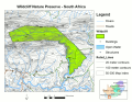
Wildcliff Atlas
These maps illustrate the location
of Wildcliff relative to Africa, the country of South Africa
and the regional topography of the Langeberg mountain range in Western Cape Province.
|
|
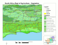
Wildcliff Environment
The maps in this series provide a
regional view of the environment in which Wildcliff
is located. They include areal representations of vegetation and soil types as well as
more specific quantitative measures related to these components.
|
|
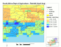
Wildcliff Climate
The existing climate data for the Wildcliff region is not very
detailed in areal extent, but most of the defining parameters have been measured.
This gallery highlights the distribution
of temperature and precipitation summerized
over different time periods.
|
Where not otherwise specified, the data used in the maps came from three major sources:
-
Digital Chart of the World (DCW).
This dataset consists of general background layers (roads, towns, streams) that
represent feature locations accurate to a approximately 2 kilometers. The DCW was
developed by ESRI for the US government in 1992.
-
South African Agriculture GIS (AGIS).
The South Africa National Department of Agriculture provides a number of valuable spatial
datasets through this distribution network. At a scale of 1:500,000, this is the best
resolution spatial data that is readily available about the environment.
-
Chief Directorate: Surveys and Mapping.
This agency is part of the South Africa Department of Land Affairs the highest resolution
data that is available at the national level. The 1:50,000 scale layers represent the
location of natural and man-made features, including 20 meter contours.
Detailed Maps and the Dynamic Map Gallery were produced by
Horizon Mapping.
We welcome
comments, or enquiries from potential volunteers or researchers.
Contact us for
information or browse the research
opportunities page.
Wildcliff is a
registered
|
 |
Conservation Area
|
|